Home » Nature » Disaster » Technical report details Bhotekoshi flood’s journey from Tibet to Devghat
Kathmandu, August 27
The Flood Forecasting Division has released a detailed technical report on the devastating floods that swept through the Bhotekoshi, Trishuli and Narayani rivers on Wednesday.
According to the report, a lake formed after the river was blocked in Tibet burst, sending a massive surge of water through the Bhotekoshi in Rasuwa and downstream along the Trishuli and Narayani river corridors.
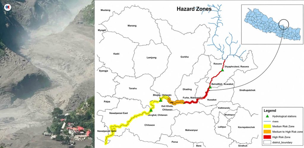
The flood swept away four automatic hydrological monitoring stations along the river system. A preliminary technical assessment estimates that around 20 million cubic metres of additional water passed through the Devghat area alone during the flood.
The Department of Mines and Geology recorded a 4.4-magnitude earthquake at 8:37am on Wednesday. Shortly afterwards, a massive flood entered the Bhotekoshi from the Tibet side.
The Flood Forecasting Division said it began sending continuous alerts and SMS warnings to people living along the riverbanks and in vulnerable settlements after receiving information about the flood.
In coordination with Nepal Telecom and Ncell, a total of 679,295 early-warning SMS messages were sent to residents in vulnerable areas of Rasuwa, Nuwakot, Dhading and Chitwan.
The messages included 435,635 SMS sent through Nepal Telecom and 243,660 through Ncell.
The report said the timely dissemination of the warnings helped many people save their lives.
The report provides the following timeline of the flood:
The intensity of the flood destroyed four hydrological monitoring stations operated under the Centre for Water Resources and Hydrology.
The affected stations were the Rasuwa Bhotekoshi station, Rasuwa Syafrubesi station, Nuwakot Betrabati station and Dhading Malekhu (Fhurke) station.
The stations were swept away along with bridges, making it impossible to obtain direct water-level data from those locations, according to the report.
A technical assessment showed that approximately 20 million cubic metres of additional floodwater passed through the Devghat station during the event.
The division has mapped the area from the Rasuwagadhi border point to the Nepal-India border into very high-, high- and medium-risk zones and issued instructions to maintain heightened vigilance.
Subscribe to Onlinekhabar English to get notified of exclusive news stories.
The English Edition of Nepal’s No 1 News Portal Onlinekhabar.com
Phone +977-1-4780076, +977-1-4786489
Email: [email protected]

Technical report details Bhotekoshi flood’s journey from Tibet to Devghat – OnlineKhabar English News